CROSS · Mont Blanc Massif (FR/IT/CH)

Tour du Mont Blanc

Multi-day hut-to-hut trek across Alpenverein huts
Tour du Mont Blanc
Moderate Cross-borderVia ferrata
chisloup · CC BY 3.0
166 km
Distance
+10,000 m
Ascent
10 days
Duration
0
Huts
Best time: June – September
Check hut availability →
Download GPX ↓

About the route

Highest point
2,844 m
Huts on the route
0 × hut
Secured sections
Via ferrata K1 · avoidable
Best time
June – September

The route at a glance

Elevation profile
↑ 9,532 m ascent↓ 9,532 m descent166 km2,533 m summit
900180026000 km33 km66 km100 km133 km166 km
Line colour = gradient (green gentle → red steep). Dots = huts. Route: © OpenStreetMap (ODbL), elevations from mapy.com.
Route mapOpen full map ↗

Plan and book

Live availability · Alpenverein

Pick a start date — for every night on the route you instantly see the free beds and book directly through the official Alpenverein system.


Choose start date
How many staying overnight
1
„free" = beds for the whole group
MonTueWedThuFriSatSun
All huts freePartly freeSelected
Start · arrival
Chamonix-Mont-Blanc
◎ Plan arrival
Chamonix-Mont-Blanc
Before the start · lodging
Stay overnight in Chamonix-Mont-Blanc
Hotels and guesthouses in Chamonix-Mont-Blanc · Booking.com
Booking.com →
1
Day 1 · traverse to Refuge de Miage

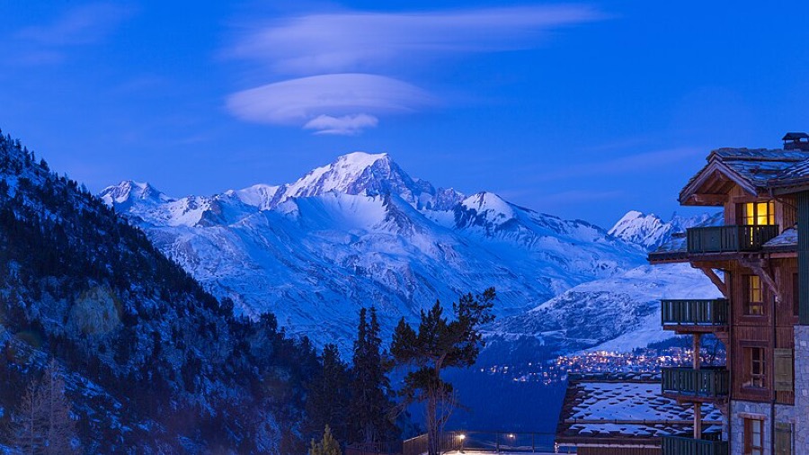
From Les Houches above Chamonix into the Miage valley, with the first glimpse of its namesake glacier beneath Mont Blanc's southwest face.

Refuge de Miage 1559 m
Valley village · lodging via Booking.com
Booking.com →
2
Day 2 · traverse to Refuge de la Croix du Bonhomme

Ascent over Col de la Croix du Bonhomme to the hut sitting directly in the mountain pass—one of the circuit's first major cols.

Refuge de la Croix du Bonhomme 2329 m
Valley village · lodging via Booking.com
Booking.com →
3
Day 3 · traverse to Rifugio Elisabetta

Over Col de la Seigne (2,516 m) you cross from France into Italy. Rifugio Elisabetta stands at the head of Val Veny beneath the Lée Blanche glacier.

Rifugio Elisabetta 2195 m
Valley village · lodging via Booking.com
Booking.com →
4
Day 4 · traverse to Rifugio Bertone

The Mont de la Saxe balcony is one of the route's finest sections: Rifugio Bertone hangs directly opposite the north face of Grandes Jorasses (4,208 m).

Rifugio Bertone 2844 m
Valley village · lodging via Booking.com
Booking.com →
5
Day 5 · traverse to Rifugio Elena

Grand Col Ferret (2,537 m) is the classic circuit's highest point and the Italy-Switzerland border. Beyond the pass, descent to Rifugio Elena.

Rifugio Elena 2061 m
Valley village · lodging via Booking.com
Booking.com →
6
Day 6 · traverse to Chalet La Peule

Through green meadows of Swiss Val Ferret to simple Chalet La Peule—the circuit's gentlest day.

Chalet La Peule 1460 m
Valley village · lodging via Booking.com
Booking.com →
7
Day 7 · traverse to Refuge Trient

Through the Trient valley beneath its namesake glacier. From here you can branch onto the challenging variant via Fenêtre d'Arpette (2,665 m).

Refuge Trient 1300 m
Valley village · lodging via Booking.com
Booking.com →
8
Day 8 · traverse to Refuge du Col de Balme

Over Col de Balme you return to the French border. From the pass opens a view back across the entire Mont Blanc massif.

Refuge du Col de Balme 2204 m
Valley village · lodging via Booking.com
Booking.com →
9
Day 9 · traverse to Refuge Lac Blanc

Around Lac Blanc—a lake where, on calm days, Grandes Jorasses and the entire Mont Blanc ridge mirror perfectly. The circuit's iconic image.

Refuge Lac Blanc 2352 m
Valley village · lodging via Booking.com
Booking.com →
Descent to the valley · Chamonix-Mont-Blanc
The loop closes back at the starting village — approximate destination, lodging below.
Chamonix-Mont-Blanc
After the trek · lodging
Stay an extra day in Chamonix-Mont-Blanc
Hotels and guesthouses in Chamonix-Mont-Blanc · Booking.com
Booking.com →
Route alert
Want the whole route on one date?
Leave your e-mail. We’ll write as soon as every hut on the route lines up with no gaps — with the dates straight to your calendar.

What to pack

Sleeping bag liner
Sleeping bag liner
Required in huts
Browse at 4camping →
Hiking boots
Hiking boots
Ankle-high, category B–C
Browse at 4camping →
Waterproof jacket
Waterproof jacket
Hardshell, 3-layer
Browse at 4camping →
Backpack 30–40 l
Backpack 30–40 l
Multi-day, with rain cover
Browse at 4camping →
Trekking poles
Trekking poles
Foldable
Browse at 4camping →
Headlamp
Headlamp
Rechargeable
Browse at 4camping →
Via ferrata set
Via ferrata set
Shock absorber + carabiners
Browse at 4camping →
Climbing helmet
Climbing helmet
Light, for via ferrata
Browse at 4camping →

Handy before you go

tips from verified partners
View on GetYourGuide
Partner · experiences
Tours and activities nearby
Guided tours, via ferratas and trips around Chamonix-Mont-Blanc — book online.
View on GetYourGuide →
Get Revolut
Partner · payments
No foreign-currency fees
A card for fee-free payments and withdrawals along the whole route — exchange rate with no markup.
Get Revolut →
Buy an eSIM on Airalo
Partner · connectivity
eSIM data in the Alps
Mobile data without roaming for the whole trek, activated in a minute.
Buy an eSIM on Airalo →

Frequently asked questions

How long is Tour du Mont Blanc and how many days does it take?+
The classic circuit measures roughly 170 km with around 10,000 meters of elevation. Most people hike it in 9 to 14 days; our plan provides ten stages from hut to hut.
How difficult is Tour du Mont Blanc?+
Technically mild—no climbing or via ferrata, just Alpine trails and passes. Physically demanding: 15 to 20 km daily with 700 to 1,000 meters elevation gain, day after day. A fit hiker with mountain experience can manage it.
Which countries does the route pass through?+
Three: France, Italy, and Switzerland. You cross borders directly at passes—from France to Italy via Col de la Seigne, Italy to Switzerland via Grand Col Ferret, back to France via Col de Balme.
Where does Tour du Mont Blanc start and end?+
Classically in Les Houches above Chamonix running counterclockwise. It is a circuit—you end where you start. But you can also start from Les Contamines, Courmayeur, or Champex.
What is the route's highest point?+
On the classic route, Grand Col Ferret at 2,537 meters on the Italy-Switzerland border. Those doing the variants via Fenêtre d'Arpette or Col des Fours climb to 2,665 meters.
Which huts are on the route?+
Per our plan: Refuge de Miage, Refuge de la Croix du Bonhomme, Rifugio Elisabetta, Rifugio Bertone, Rifugio Elena, Chalet La Peule, a hut in Trient valley, Refuge du Col de Balme, and Refuge du Lac Blanc.
How are huts booked on Tour du Mont Blanc?+
Each separately—no single club manages them. Most require email inquiry and forms; some have online systems. Reservations for the next season open in late September and October, and the best beds disappear within days.
When is the best time for Tour du Mont Blanc?+
From late June through mid-September. Passes are snowfree and huts operate. Outside this season it is cold up high and huts are closed.
Is there via ferrata or climbing on the route?+
No. Tour du Mont Blanc is purely a hiking circuit on marked trails. No fixed ropes or climbing—just walking, passes, and elevation change.
What peaks and glaciers will I see?+
Beyond Grand Col Ferret open views of Grandes Jorasses (4,208 m), Mont Dolent, and Aiguille de Triolet. You pass glaciers of Miage, Lée Blanche, and Trient, and on the penultimate day, Lac Blanc reflecting the entire massif.
Must I hire a guide or can I do it solo?+
You can do it solo with multiday trek experience and hut bookings arranged well in advance. The trail is well marked. The main obstacle is not terrain but securing lodging in time.
What is UTMB and how does it relate to this route?+
UTMB (Ultra-Trail du Mont-Blanc) is an ultramarathon following the entire circuit. Racers complete it in under one night with a 46-hour-30-minute limit. You will take ten days on the same route—and gain far more from the experience.

Similar routes

Show all routes →
Alpe-Adria-TrailEasy
Alpe-Adria-Trail
High Tauern → Trieste (AT/SI/IT)
750 km43 days
Salzburg–TerstHard
Salzburg–Terst
Eastern Alps (AT/SI/IT)
500 km28 days
E5 Oberstdorf–Merano (komplet)Hard
E5 Oberstdorf–Merano (komplet)
Allgäu / Lechtal / Ötztal (DE/AT/IT)
140 km6-8 days